

Loading…
Loading…
Loading…
Eduqas GCSE Geography A · C111
Eduqas C111 · 5.2.1 Weather Hazards: Causes and Responses Check the specification (PDF) (opens in a new tab)
A tropical cyclone is a powerful, rotating low-pressure system that develops over warm tropical oceans. It brings several connected hazards: destructive winds, intense rainfall and coastal flooding from a storm surge. These become disasters when they affect exposed communities, buildings and livelihoods.
The same type of weather system has different regional names. Hurricanes affect the North Atlantic, including the Caribbean and Gulf of Mexico, and the eastern North Pacific off Mexico. Typhoons affect the western North Pacific, including the Philippines and South China Sea. Cyclones affect the Indian Ocean, including the Bay of Bengal, and waters around northern Australia.
Tropical cyclones generally develop between about 5° and 30° north and south of the Equator. They need a deep supply of warm ocean water, usually above about 27°C, to provide heat and moisture. They rarely form directly on the Equator because the Coriolis effect there is too weak to organise the rotating system.
Warm water encourages evaporation. Warm, moist air rises, leaving lower pressure near the sea surface. As the rising air cools, water vapour condenses into cloud droplets. Condensation releases heat, which helps the air continue rising. More air is drawn towards the low-pressure centre, supplying further moisture and helping the storm strengthen.
The Earth's rotation deflects the incoming air, producing an organised rotating system. Tropical cyclones rotate anticlockwise in the Northern Hemisphere and clockwise in the Southern Hemisphere. The relatively calm eye is surrounded by the eyewall, where the strongest winds occur. Tall storm clouds produce heavy rainfall.
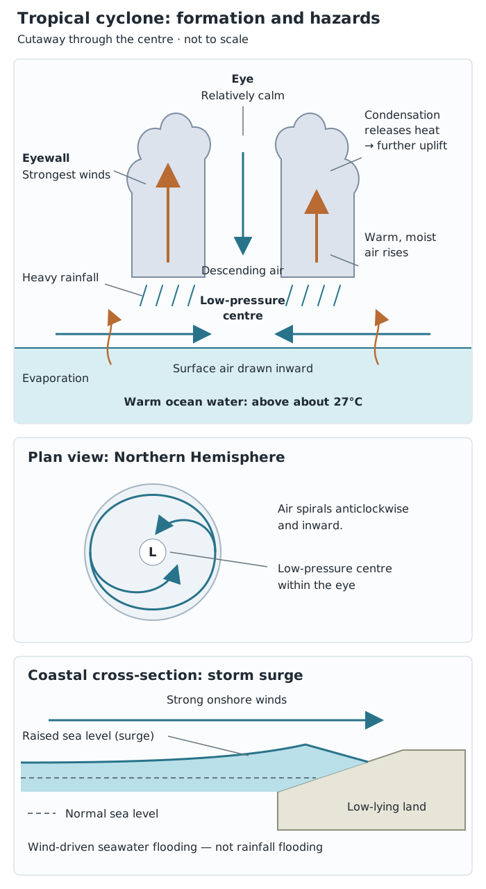
Warm ocean water supplies heat and moisture to a rotating low-pressure storm. Its winds, rainfall and storm surge create different but connected hazards.
Strong winds can damage buildings and vegetation. Heavy rain can flood rivers and settlements. At the coast, winds push seawater towards the land, creating a storm surge. This rise in sea level can flood low-lying coastal areas; it is different from flooding caused by rainfall.
The distribution is not a continuous band around the world. Look for concentrations over particular warm ocean basins and nearby coastlines: the Caribbean and Gulf of Mexico, the western Pacific around the Philippines, the Bay of Bengal, and northern Australia.
When interpreting a distribution map, first identify the Equator and latitude lines. Then describe the main ocean basins affected, followed by nearby countries or regions. Explain the pattern using the need for warm water and sufficient rotational influence. A concentration close to tropical coastlines is significant because storms can transfer their wind, rainfall and surge hazards onto densely settled land.
Distinguish the formation area, the storm track and the area affected. A cyclone can develop over the ocean and later move towards a different region. Its impacts are therefore not restricted to the exact location where it formed.
Tropical cyclones are seasonal because ocean temperatures change during the year. Activity is concentrated in the warmer part of the year: broadly June to October in many Northern Hemisphere tropical basins, and December to March in Southern Hemisphere basins. These are broad patterns, not identical calendars for every ocean basin.
Seasonality involves both temporal change, meaning change through time, and spatial change, meaning change in location. A region's risk rises during its storm season, while the main zone of activity differs between the hemispheres.
The tropical rain belt also changes location seasonally. The Intertropical Convergence Zone (ITCZ) follows the zone of strongest solar heating, moving northwards during the Northern Hemisphere summer and southwards during the Southern Hemisphere summer. As this low-pressure belt moves, the areas experiencing rising air and heavy rainfall move too.
This helps explain contrasting tropical wet and dry seasons. A monsoon is a seasonal wind pattern, not an individual tropical cyclone. In summer, strongly heated land develops lower pressure and draws in moist air from the sea, bringing heavy rain. In winter, cooler land develops higher pressure and winds generally bring drier conditions. Both monsoon rainfall and tropical cyclones can cause flooding, but they are different weather processes.
Warmer oceans can supply more energy to tropical cyclones, increasing their potential intensity. A warmer atmosphere can also hold more moisture, allowing heavier rainfall. Rising sea levels mean that a storm surge starts from a higher baseline, increasing coastal flood risk.
However, storm frequency and magnitude must be considered separately. The total global number of tropical cyclones is not expected simply to rise everywhere. It may remain similar or decrease slightly, while a greater proportion of storms become very intense. An increase in the strongest category 4 and 5 storms has been reported since the 1970s.
The areas with sufficiently warm water may extend somewhat beyond their previous limits, potentially exposing some places just beyond the tropics. This does not mean tropical cyclones will spread across the whole globe: suitable atmospheric conditions and sufficient rotational influence are still needed. Changes also differ between ocean basins, so a single worldwide prediction should not be applied equally to every region.
Typhoon Haiyan, also known locally as Yolanda, struck the Philippines on 8 November 2013. The Philippines is an island country in the western Pacific, east of Vietnam. Haiyan was a category 5 storm, with sustained winds of about 195 mph at landfall.
Haiyan developed over the western Pacific and travelled westwards towards the Philippines. Sea temperatures of about 30°C supplied heat and moisture, supporting rapid intensification. Rising moist air, condensation and rotation produced an exceptionally powerful low-pressure system.
The storm's physical strength was only part of the disaster. Coastal settlements were exposed to its surge. Tacloban, on Leyte, lies at the end of a funnel-shaped bay: seawater driven into the narrowing bay became concentrated, worsening coastal flooding. The location of people and buildings therefore increased the consequences of the hazard.
People: around 6,200 people died, more than 4 million were displaced, and about 1.1 million homes were lost. Destroyed homes left survivors needing shelter, food, safe water and medical care. Disrupted sanitation and limited clean water increased the risk of disease. Two months later, around 21,000 families were still living in evacuation centres, showing that displacement continued well beyond the storm itself.
Environment: flooding and strong winds damaged forests and trees. Oil and sewage entered local ecosystems, while damaged sanitation increased pollution. Coconut plantations were devastated. Fallen and rotting timber attracted pests, threatening surviving trees and making recovery more difficult.
Economy: losses were estimated at around US$13 billion. Major rice- and sugar-producing areas were damaged, with over 130,000 tonnes of rice lost. Destruction of coconut trees damaged an important source of agricultural income. Fishing communities also suffered, while damaged settlements and disrupted transport increased the cost and difficulty of recovery.
These categories connect. Losing crops is an environmental impact, but it also removes farmers' income and reduces food supplies. Destruction of a home is a social impact, while rebuilding it places financial pressure on the family and government. Poorer households generally have fewer resources available to recover.
Before landfall, the Philippines used forecasts, public storm warnings, risk maps and evacuation shelters. The weather agency PAGASA increased its warnings as Haiyan intensified. Aircraft and helicopters were positioned in advance to support the response. On Tulang Diyot, all 1,000 residents evacuated before the storm, demonstrating the value of community preparation and early action.
Warning alone was not enough. People needed somewhere safe to go, and there were concerns that some buildings designated as shelters would not withstand the winds. Effective preparedness therefore required both clear communication and suitable shelter.
Immediately afterwards, emergency teams and international organisations supplied relief. Twelve International Federation of Red Cross emergency response units were deployed. Heavy lifting equipment from the UK and USA helped clear debris at Tacloban airport so aid could move through it.
Nevertheless, debris slowed rescue vehicles, and airport and harbour closures disrupted distribution. Survivors experienced shortages of food and water, and the UN acknowledged that its response had been too slow. Previous disasters had also reduced the Philippines' available financial, material and human resources.
Recovery required more than emergency supplies: homes, farming livelihoods and essential services needed rebuilding. The continued presence of families in evacuation centres showed the difficulty of moving from immediate relief to lasting recovery.
Overall, preparation and evacuation reduced exposure in some communities, while international assistance provided essential resources after landfall. However, vulnerable shelters, disrupted transport and limited resources restricted their effectiveness. Haiyan shows why reducing disaster losses requires a combination of early warning, safe evacuation, resilient infrastructure and sustained recovery support.
Describe distribution using latitude, named oceans and affected regions, rather than saying only ‘near the Equator’.
Distinguish frequency (how often storms occur) from magnitude (how powerful they are). More intense storms do not necessarily mean more storms overall.
For Haiyan, link each consequence to a cause: for example, the funnel-shaped bay concentrated the storm surge, increasing flooding in Tacloban.
Assess responses by explaining both their benefits and limitations, then reach a supported judgement.
Keep observed changes separate from predictions about future tropical storms.
It can see this note and what your specification asks for.
Answers are free with an account.
1 free note left this week
Get more free notesYour answer sets when this note comes back for review, or marks it complete.
Was this note helpful?
Log in to tell us whether it helped, or to report a problem.
Last updated
Tropical cyclone
A large, rotating low-pressure weather system that develops over warm tropical oceans and produces powerful winds and heavy rain.
Atmospheric pressure
The force exerted by the weight of air above a surface. In a low-pressure area, air rises and surrounding air moves towards it.
Coriolis effect
The apparent deflection of moving air caused by the Earth's rotation, helping tropical cyclones to rotate.
Storm surge
An abnormal rise in sea level during a storm, mainly caused by strong winds pushing seawater towards the coast.
Eyewall
The ring of towering storm clouds around a tropical cyclone's eye, where its strongest winds occur.
Frequency
The number of times an event occurs within a given period.
Magnitude
The size or strength of an event, such as the wind speed of a tropical cyclone.
Monsoon
A seasonal change in prevailing winds that produces contrasting wet and dry seasons.
Intertropical Convergence Zone
A tropical belt of low pressure where the trade winds meet, causing warm, moist air to rise and produce heavy rainfall.
Hazard mitigation
Actions taken to reduce the harmful effects of a hazard, such as evacuation planning and stronger shelters.
Put your knowledge into practice — try past paper questions for Geography A
Tropical cyclone
A large, rotating low-pressure weather system that develops over warm tropical oceans and produces powerful winds and heavy rain.
Atmospheric pressure
The force exerted by the weight of air above a surface. In a low-pressure area, air rises and surrounding air moves towards it.
Coriolis effect
The apparent deflection of moving air caused by the Earth's rotation, helping tropical cyclones to rotate.
Storm surge
An abnormal rise in sea level during a storm, mainly caused by strong winds pushing seawater towards the coast.
Eyewall
The ring of towering storm clouds around a tropical cyclone's eye, where its strongest winds occur.
Frequency
The number of times an event occurs within a given period.
Magnitude
The size or strength of an event, such as the wind speed of a tropical cyclone.
Monsoon
A seasonal change in prevailing winds that produces contrasting wet and dry seasons.
Intertropical Convergence Zone
A tropical belt of low pressure where the trade winds meet, causing warm, moist air to rise and produce heavy rainfall.
Hazard mitigation
Actions taken to reduce the harmful effects of a hazard, such as evacuation planning and stronger shelters.
Philippines, 8 November 2013; category 5; about 195 mph winds.