

Loading…
Loading…
Loading…
Eduqas GCSE Geography A · C111
Eduqas C111 · 5.2.1 Weather Hazards: Causes and Responses Check the specification (PDF) (opens in a new tab)
The Sun heats Earth unevenly. Near the equator, sunlight strikes the surface more directly, concentrating energy over a smaller area. Towards the poles, sunlight arrives at a lower angle and spreads over a larger area. This produces a temperature difference between the warmer tropics and the colder polar regions.
Global atmospheric circulation is the large-scale movement of air that redistributes this heat, as well as moisture. It helps reduce the temperature contrast between the equator and the poles. Individual weather systems change constantly, but their movements form a broad circulation pattern when averaged over many years.
Atmospheric pressure is the force exerted by the atmosphere on Earth's surface. It is measured in hectopascals, or hPa. An area has high or low pressure compared with the areas around it.
When air near the surface warms, it expands, becomes less dense and rises. Where air rises and flows away at altitude, low pressure develops at the surface. Nearby surface air moves in to replace it. As rising air cools, water vapour can condense into water droplets, forming clouds and potentially rain.
Where air sinks, high pressure develops at the surface, and air spreads outwards near the ground. Although the air may have cooled before descending, it warms as it sinks and is compressed. This reduces condensation and generally limits cloud formation, bringing drier, more settled weather.
Each hemisphere has three main circulation cells: the Hadley, Ferrel and Polar cells. A cell is a large circulation loop linking surface air movement with movement higher in the atmosphere.
In the Hadley cell, strong heating makes air rise near the equator. Trade winds from the Northern and Southern Hemispheres meet here in the Intertropical Convergence Zone (ITCZ). This convergence and rising air create an equatorial belt of low pressure, with frequent thunderstorms and heavy rain.
The rising air then moves towards higher latitudes at altitude. It cools and eventually sinks in the subtropics, around 30–40° north and south, creating belts of high pressure. Some surface air returns towards the equator as the trade winds, completing the Hadley circulation. The sinking air helps explain the dry conditions of hot deserts such as the Sahara.
The Ferrel cell lies between the subtropics and approximately 60–70° latitude. At its poleward boundary, warmer air from lower latitudes meets cold polar air. Air rises along this boundary, creating a belt of low pressure and unsettled weather. Higher in the atmosphere, air returns towards the subtropics, where it joins the sinking air of the Hadley cell.
In the Polar cell, cold, dense air sinks over the poles, creating high pressure. It flows towards lower latitudes at the surface and rises where it meets warmer air around 60–70°. Air then returns polewards at altitude.
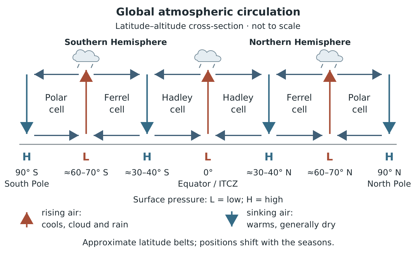
The three-cell model links rising air with low-pressure belts and sinking air with high-pressure belts. It shows the broad average pattern; boundaries vary and shift with the seasons.
The main surface-pressure sequence from the equator to either pole is therefore low → high → low → high. These are broad average belts, not fixed boundaries: their positions vary, and the ITCZ shifts with the seasons.
Pressure differences drive wind from higher towards lower pressure. A greater pressure difference over a given distance generally produces stronger winds. Weather charts show pressure using isobars, which join places with equal pressure; closely spaced isobars indicate a steeper pressure gradient and generally stronger winds.
Earth's rotation deflects moving air through the Coriolis effect: to the right in the Northern Hemisphere and to the left in the Southern Hemisphere. This helps create the trade winds and the prevailing westerly winds of the middle latitudes. It also makes winds spiral around pressure systems. In the Northern Hemisphere, winds circulate anticlockwise around lows and clockwise around highs; the directions reverse in the Southern Hemisphere.
Low-pressure systems, or depressions, generally bring unsettled weather because air rises, cools and forms clouds. Heavy rain can overwhelm drainage and cause flash flooding. Prolonged rainfall can also lead to river flooding. Strong pressure gradients around a depression can produce damaging winds.
Around the UK's latitudes, warmer, moist air meets colder polar air at the polar front. Rising air and travelling depressions help explain the UK's changeable, wet and windy weather. The jet stream, a fast-moving ribbon of air high in the atmosphere, helps steer these systems. If a depression stalls, rainfall and strong winds can continue for longer, increasing the hazard.
Tropical cyclones, including hurricanes and typhoons, are particularly powerful tropical low-pressure systems. Warm seas, normally around 27°C or above, supply warm, moist air. This air rises, and condensation releases heat that helps sustain further rising air and storm development. Converging surface winds, little change in wind with height and sufficient distance from the equator for rotation are also needed.
Their hazards include destructive winds, intense rainfall and coastal flooding from storm surges, when seawater is driven onto the coast. Ordinary low pressure does not automatically develop into a tropical cyclone.
High-pressure systems, or anticyclones, usually bring light winds and settled conditions because sinking air suppresses cloud formation. These conditions can become hazardous when they persist.
In summer, clear skies allow strong sunshine to heat the surface day after day. A persistent anticyclone can therefore contribute to a heatwave, placing people at risk of heat-related illness. Meanwhile, a prolonged lack of rain can cause drought, reducing water supplies and damaging crops. Heat increases water loss through evaporation, which can worsen the shortage.
Sometimes an anticyclone becomes stationary and blocks the usual passage of rain-bearing weather systems. This blocking can prolong hot or dry conditions. The duration of the pressure system matters: a few fine days are very different from weeks without useful rain.
High pressure is not always warm. In winter, clear skies allow the ground to lose heat at night, bringing cold conditions and frost. Pressure systems influence weather, but the resulting hazard also depends on the season, location and how long the conditions last.
Uneven solar heating drives air movement and transfers heat and moisture between the equator and poles.
| Location | Air movement | Surface pressure |
|---|---|---|
| Equator: ITCZ | Air converges and rises | Low |
| Subtropics: around 30–40° N/S | Air sinks | High |
| Around 60–70° N/S | Warmer and polar air meet; air rises | Low |
| Poles | Cold air sinks | High |
Cells from equator to pole: Hadley → Ferrel → Polar. Boundaries are approximate and shift.
Build explanations as linked chains: air rises → cools → water vapour condenses → clouds and rain form → heavy or prolonged rain may cause flooding.
For global circulation, connect each pressure belt to rising or sinking air. Cell boundaries are approximate, not fixed lines.
High pressure does not always mean hot weather: persistent summer high pressure can cause heatwaves, whereas winter high pressure can bring cold conditions and frost.
Do not describe every low-pressure system as a hurricane. Tropical cyclones need warm tropical seas and other suitable conditions.
It can see this note and what your specification asks for.
Answers are free with an account.
1 free note left this week
Get more free notesYour answer sets when this note comes back for review, or marks it complete.
Was this note helpful?
Log in to tell us whether it helped, or to report a problem.
Last updated
Global atmospheric circulation
The large-scale movement of air around Earth that redistributes heat and moisture between the equator and the poles.
Atmospheric pressure
The force exerted by the atmosphere on Earth's surface, measured in hectopascals (hPa). High and low pressure are defined relative to surrounding areas.
Circulation cell
A large-scale circulation loop in which air moves between Earth's surface and the upper atmosphere.
Hadley cell
A tropical circulation cell in which air rises near the equator, moves polewards at altitude, sinks in the subtropics and returns towards the equator near the surface.
Ferrel cell
The middle-latitude circulation cell between the Hadley and Polar cells, with surface air moving towards higher latitudes and generally producing westerly winds.
Polar cell
A high-latitude circulation cell in which air sinks over the poles, moves towards lower latitudes at the surface and rises where it meets warmer air.
Intertropical Convergence Zone (ITCZ)
A belt of low pressure near the equator where trade winds from both hemispheres meet, causing air to rise and often producing thunderstorms and heavy rain.
Coriolis effect
The deflection of moving air caused by Earth's rotation: to the right in the Northern Hemisphere and to the left in the Southern Hemisphere.
Depression
An area of relatively low atmospheric pressure, generally associated with rising air, clouds and unsettled weather.
Anticyclone
An area of relatively high atmospheric pressure, generally associated with sinking air and settled weather.
Isobar
A line on a weather chart joining places with equal sea-level atmospheric pressure.
Jet stream
A fast-moving ribbon of air high in the atmosphere that helps steer weather systems.
Put your knowledge into practice — try past paper questions for Geography A
Global atmospheric circulation
The large-scale movement of air around Earth that redistributes heat and moisture between the equator and the poles.
Atmospheric pressure
The force exerted by the atmosphere on Earth's surface, measured in hectopascals (hPa). High and low pressure are defined relative to surrounding areas.
Circulation cell
A large-scale circulation loop in which air moves between Earth's surface and the upper atmosphere.
Hadley cell
A tropical circulation cell in which air rises near the equator, moves polewards at altitude, sinks in the subtropics and returns towards the equator near the surface.
Ferrel cell
The middle-latitude circulation cell between the Hadley and Polar cells, with surface air moving towards higher latitudes and generally producing westerly winds.
Polar cell
A high-latitude circulation cell in which air sinks over the poles, moves towards lower latitudes at the surface and rises where it meets warmer air.
Intertropical Convergence Zone (ITCZ)
A belt of low pressure near the equator where trade winds from both hemispheres meet, causing air to rise and often producing thunderstorms and heavy rain.
Coriolis effect
The deflection of moving air caused by Earth's rotation: to the right in the Northern Hemisphere and to the left in the Southern Hemisphere.
Depression
An area of relatively low atmospheric pressure, generally associated with rising air, clouds and unsettled weather.
Anticyclone
An area of relatively high atmospheric pressure, generally associated with sinking air and settled weather.
Isobar
A line on a weather chart joining places with equal sea-level atmospheric pressure.
Jet stream
A fast-moving ribbon of air high in the atmosphere that helps steer weather systems.