

Loading…
Loading…
Loading…
Eduqas GCSE Geography B · C112
Eduqas C112 · 2.2.1 Development of River Landscapes Check the specification (PDF) (opens in a new tab)
A river landscape includes more than the channel containing the water. It also includes valley sides, bends, flat land beside the river and the river mouth. Fluvial processes are processes involving flowing river water. Rivers erode material, transport it downstream and deposit it elsewhere. These processes work together with weathering, mass movement and human activity to shape distinctive UK landscapes.
Weathering breaks down rock where it lies. For example, in freeze–thaw weathering, water enters cracks, freezes and expands; repeated freezing and thawing can loosen rock fragments. Mass movement then carries material downhill under gravity, through processes such as rockfalls or soil sliding. Material reaching the river becomes part of its load: it may be carried away and may help the river erode its bed and banks.
The balance of processes varies along a river. In the upper course, steep gradients favour downward, or vertical, erosion and narrow valleys. Farther downstream, sideways, or lateral, erosion and deposition help create bends and wider valley floors. These are typical patterns, not fixed boundaries: rock resistance and local conditions also matter.
Hydraulic action is erosion by the force of moving water. Water strikes the bed and banks and forces its way into cracks. Pressure, including the compression of trapped air, helps loosen material, which the river can remove.
Abrasion occurs when the river's load scrapes and strikes the bed and banks. Stones dragged along the bed act rather like sandpaper, wearing away the rock beneath them. Abrasion therefore requires both moving water and material capable of wearing down the channel.
Attrition changes the load itself. Rock fragments collide as they move, chipping off sharp edges. Over time, they become smaller and more rounded. Unlike abrasion, attrition does not directly describe the wearing away of the river bank.
Solution is chemical erosion. Slightly acidic water can dissolve soluble rock such as limestone. The dissolved substances are then carried within the water, even though they cannot be seen as separate particles.
A river transports different parts of its load in different ways. Particle size and the strength of the flow both influence how material moves.
Imagine watching a river during a strong flow: a large stone may roll along the bottom while fine sediment travels in the water above it. If the current weakens, the river may no longer be able to move the stone, even though it continues carrying finer material.
Deposition occurs when a river can no longer carry part of its load. A reduction in velocity commonly causes solid sediment to be deposited, with larger particles generally settling before finer ones. This happens where water slows on the inside of bends, spreads across a floodplain or enters quieter water near the mouth. Dissolved substances do not simply settle out like pebbles when the flow slows.
A V-shaped valley has a narrow floor and steep sides, giving it the shape of the letter V in cross-section. These valleys are typical of the upper course.
Hydraulic action and abrasion deepen the river channel through vertical erosion. As the river cuts down, rock on the valley sides becomes exposed to weathering. Loosened material moves down the slopes under gravity and enters the channel, where the river removes it. Repeated downcutting, weathering and mass movement produce the valley's steep, sloping sides.
This explains why the valley is not shaped by the river alone. The river mainly cuts into its floor, while weathering and mass movement reshape its sides. Resistant rock can maintain steeper slopes; vegetation can help bind soil and reduce some slope movement.
A waterfall can develop where resistant rock overlies less resistant rock. The less resistant rock erodes more quickly, creating a step over which the water falls. The difference in erosion rates is called differential erosion.
At the foot of the waterfall, hydraulic action and abrasion deepen a plunge pool. Erosion also undercuts the less resistant rock beneath the resistant layer, leaving an unsupported overhang. Eventually, the overhang collapses under gravity. Fallen blocks can provide material for further abrasion in the plunge pool.
Undercutting and collapse happen repeatedly, moving the waterfall upstream. Its retreat leaves a narrow, steep-sided gorge along its former position. Waterfalls and their associated gorges therefore belong to the same sequence of landscape development.
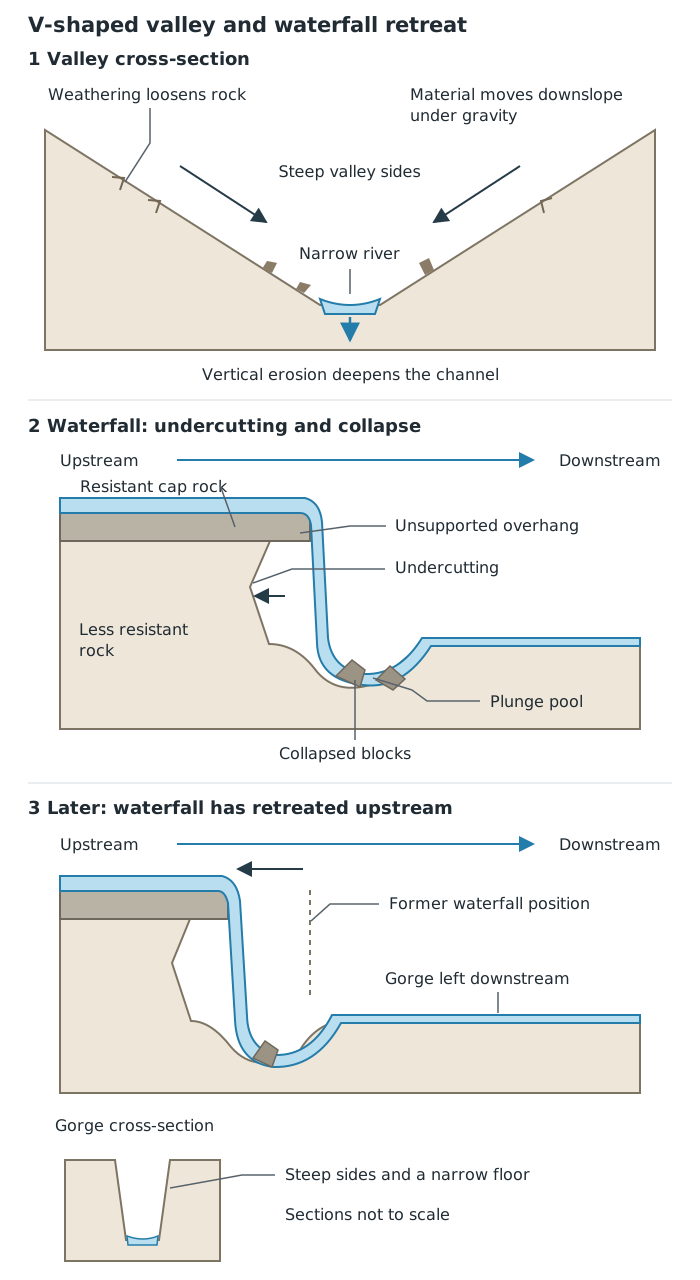
Valley slopes develop through weathering and mass movement alongside river erosion. Repeated undercutting and collapse make a waterfall retreat, leaving a gorge.
A meander is a bend in a river. Meanders are common in the middle and lower courses, where sideways erosion helps widen the valley.
Across a bend, flow is usually faster and the channel deeper towards the outside. Hydraulic action and abrasion erode the outside bank, creating a steep river cliff. Towards the inside, shallower, slower water deposits sediment, forming a gently sloping slip-off slope.
Together, outside-bank erosion and inside-bank deposition make a bend grow and change position. A meander is therefore not a permanent curve fixed in the landscape: its channel can migrate across the valley floor over time.
As a meander becomes more pronounced, erosion on the outside banks brings the two sides of its neck closer together. Eventually, often during a flood, the river cuts through the narrow neck and takes a shorter route.
The old loop is initially still connected to the main channel. With much less flow passing around it, water slows and sediment is deposited at its entrances. Deposition seals both ends, leaving a separate, curved ox-bow lake.
The sequence needs both processes: erosion narrows and cuts through the neck; deposition separates the abandoned bend from the river.
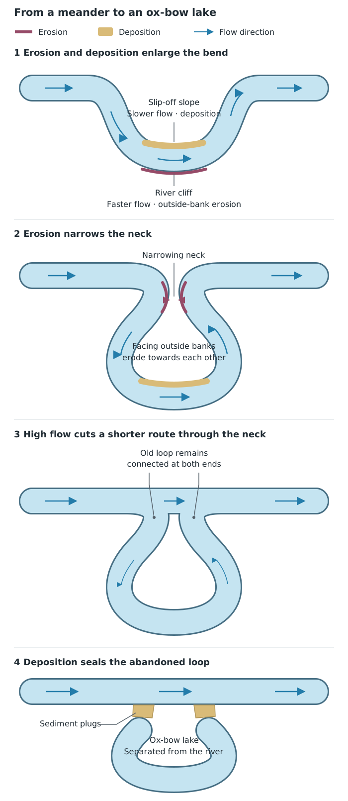
Erosion enlarges the bend and narrows its neck. After a cut-through, deposition seals the old loop to form an ox-bow lake.
A floodplain is relatively flat land on either side of a river that can be covered when the river overflows its banks. It is often particularly wide in the lower course.
Lateral erosion and meander migration widen the valley floor. During floods, water spreads beyond the channel across this land. Increased friction and spreading reduce its velocity, causing sediment to be deposited as alluvium. Repeated flooding adds layers of sediment across the valley floor, helping create a broad, relatively flat surface.
Coarser sediment is often deposited close to the channel, while finer particles travel farther across the floodplain. Repeated deposition near the banks can build raised natural embankments called levees. These are depositional features, not simply another name for every river bank.
An estuary is the tidal mouth of a river, where freshwater meets seawater. Its landscape is shaped by both river flow and tidal movement.
Where water becomes slower or quieter, fine sediment can accumulate. This creates mudflats, which are exposed at low tide and covered as the tide rises. Vegetation can colonise suitable deposits, trapping more sediment and helping saltmarshes develop. Tidal currents can also erode and redistribute sediment, so an estuary is not uniformly a place of deposition.
Estuary landscapes can also be altered by people. Cardiff Bay previously had mudflats exposed at low tide. A barrage built across the bay retained water, changing the tidal landscape into a permanently water-covered area. This shows how controlling water movement can transform a river mouth rather than merely changing the channel upstream.
Building a dam across a river holds back water and floods land upstream, creating a reservoir. A flowing channel and parts of its valley become a body of stored water. Farmland, habitats and settlements may be submerged.
Water slows as it enters the reservoir, encouraging sediment to settle. The dam therefore interrupts the movement of both water and sediment downstream. Controlled releases alter the natural flow, and less frequent downstream flooding can reduce the deposition of fertile alluvium. Sudden releases can also cause downstream erosion.
Reservoirs can provide water supplies, recreation and, where suitable, hydroelectric power. They can also help regulate flood flows. These benefits must be weighed against the loss of valley land, changes to habitats and disruption of natural river processes.
Dredging removes accumulated sediment, such as silt, from the river bed. This deepens the channel and increases the space available to carry water. It can help maintain navigation and reduce local flood risk where sediment build-up restricts channel capacity. However, it directly changes the bed, disturbs habitats and may need repeating as sediment continues to arrive and be deposited.
Removing sediment also changes the variety of shallow and deep areas within a channel. These differences in depth, flow and bed material provide habitats for aquatic plants, invertebrates and fish. Dredging can lower normal water levels, leaving previously wet sediment shelves exposed and reducing their value as aquatic habitats.
On the River Eden in Kent, periodic dredging and vegetation clearance altered the channel. Even limited sediment removal reduced the ecological value of sediment features as water levels fell. There was also evidence suggesting that dredging upstream reduced the supply of sediment downstream and encouraged erosion there. However, where work was carried out sensitively and habitats along the channel margins were retained, invertebrate populations were little affected or recovered quickly. Dredging therefore has benefits and costs: its frequency and extent should reflect the actual need for extra channel capacity rather than assuming that routine removal is always beneficial.
Channel straightening replaces a winding route with a shorter, straighter one. It is sometimes combined with widening and deepening. Water can pass through the modified stretch more quickly, which can improve navigation and reduce local flood risk. The landscape loses natural bends, and engineering can remove varied banks and habitats.
Faster movement through one stretch can transfer problems downstream. Where the flow subsequently slows, deposition can build up again, creating a need for further dredging. Thus, an intervention may benefit a settlement beside the modified channel while causing environmental changes elsewhere.
Natural processes and human modifications are connected: changing the channel or controlling the flow changes where erosion, transportation and deposition occur. River landscapes continue to adjust after engineering work is completed.
For a landform explanation, link each process to the next change: erosion undercuts the waterfall, the overhang collapses, the waterfall retreats and a gorge remains.
Distinguish abrasion, which wears away the bed and banks, from attrition, which wears down the transported load.
Solution has two roles: dissolving rock is erosion; carrying the dissolved substances downstream is transportation.
In meander diagrams, label erosion on the outside bend and deposition on the inside bend. Show deposition sealing both ends of a cut-off meander.
When explaining human modification, distinguish benefits in the modified stretch from possible effects downstream. Reducing local flood risk does not mean removing flood risk everywhere.
It can see this note and what your specification asks for.
Answers are free with an account.
1 free note left this week
Get more free notesYour answer sets when this note comes back for review, or marks it complete.
Was this note helpful?
Log in to tell us whether it helped, or to report a problem.
Last updated
Fluvial process
A process involving flowing river water, such as erosion, transportation or deposition.
Erosion
The wearing away and removal of material by moving water, ice or wind.
Weathering
The breakdown or chemical alteration of rock in place, without its removal by a transporting agent.
Mass movement
The downhill movement of rock or soil under gravity.
Hydraulic action
Erosion caused by the force of moving water against a river's bed and banks, including pressure within cracks.
Abrasion
The wearing away of a river's bed and banks by sediment carried by the water.
Attrition
The wearing down of transported rock fragments as they collide, making them smaller and more rounded.
Solution
The dissolving of soluble rock by water; also the transportation of dissolved substances within river water.
Load
Material transported by a river, including rock fragments, fine sediment and dissolved substances.
Traction
The rolling or sliding of large particles along a river bed.
Saltation
The bouncing of smaller particles, such as pebbles, along a river bed.
Suspension
The transportation of fine particles within flowing water rather than along the river bed.
Deposition
The laying down of transported material when a river can no longer carry it.
V-shaped valley
A narrow river valley with steep sides forming a V-shaped cross-section.
Gorge
A narrow, steep-sided valley, which can be formed by the upstream retreat of a waterfall.
Meander
A bend in a river channel.
Ox-bow lake
A curved lake formed when a meander is cut off from the main river channel.
Floodplain
Relatively flat land beside a river that is covered by water when the river overflows its banks.
Alluvium
Sediment deposited by a river.
Estuary
The tidal mouth of a river, where freshwater meets seawater.
Reservoir
A body of water stored for use or management, often created by building a dam across a river valley.
Dredging
The removal of accumulated sediment from a river channel.
Put your knowledge into practice — try past paper questions for Geography B
Fluvial process
A process involving flowing river water, such as erosion, transportation or deposition.
Erosion
The wearing away and removal of material by moving water, ice or wind.
Weathering
The breakdown or chemical alteration of rock in place, without its removal by a transporting agent.
Mass movement
The downhill movement of rock or soil under gravity.
Hydraulic action
Erosion caused by the force of moving water against a river's bed and banks, including pressure within cracks.
Abrasion
The wearing away of a river's bed and banks by sediment carried by the water.
Attrition
The wearing down of transported rock fragments as they collide, making them smaller and more rounded.
Solution
The dissolving of soluble rock by water; also the transportation of dissolved substances within river water.
Load
Material transported by a river, including rock fragments, fine sediment and dissolved substances.
Traction
The rolling or sliding of large particles along a river bed.
Saltation
The bouncing of smaller particles, such as pebbles, along a river bed.
Suspension
The transportation of fine particles within flowing water rather than along the river bed.
Deposition
The laying down of transported material when a river can no longer carry it.
V-shaped valley
A narrow river valley with steep sides forming a V-shaped cross-section.
Gorge
A narrow, steep-sided valley, which can be formed by the upstream retreat of a waterfall.
Meander
A bend in a river channel.
Ox-bow lake
A curved lake formed when a meander is cut off from the main river channel.
Floodplain
Relatively flat land beside a river that is covered by water when the river overflows its banks.
Alluvium
Sediment deposited by a river.
Estuary
The tidal mouth of a river, where freshwater meets seawater.
Reservoir
A body of water stored for use or management, often created by building a dam across a river valley.
Dredging
The removal of accumulated sediment from a river channel.
Connect local benefits with wider changes to erosion, sediment movement, habitats and valley land use.