

Loading…
Loading…
Loading…
OCR GCSE Geography A · J383
OCR J383 · 1.1.1 Check the specification (PDF) (opens in a new tab)
The UK’s physical landscape varies from rugged mountains to gently rolling hills and flat plains. Relief describes the height and shape of this land. Uplands are relatively high areas, often with steep slopes; lowlands are relatively low areas, usually with gentler terrain.
A glaciated landscape is one that has been shaped by ice in the past. This describes its history rather than simply its height. Much of the UK’s upland landscape is also glaciated, but ice affected some lower areas too. Geology, climate and human activity help explain why these landscapes look different.
The UK’s uplands are concentrated in the north and west, including much of Scotland, Wales, northern England and parts of Northern Ireland. Examples include the Grampian Mountains in Scotland, Snowdonia in Wales and the Lake District in north-west England. Their terrain is often rugged: rocky, uneven and steep.
Lowlands are concentrated in central, southern and eastern England. Norfolk, the Cotswolds and the South Downs are examples. Lowland does not mean completely flat: the Cotswolds and South Downs include rolling hills. The national contrast is between generally higher, steeper land in the north and west and generally lower, gentler land in the south and east.
Geology means the rocks of an area, including their types and structures. Rocks differ in their resistance to weathering and erosion, so they do not all wear away at the same rate.
Much upland Britain contains resistant igneous and metamorphic rocks. Igneous rocks, such as granite and basalt, form when molten rock cools and solidifies. Metamorphic rocks form when existing rocks are changed by heat and pressure without melting. For example, shale can become slate. Resistant rocks can remain as high ground while surrounding, less resistant material is worn away.
Past plate movements also helped create uplands. Collisions folded and uplifted rocks, contributing to mountain landscapes such as the Scottish Highlands. Heat and pressure changed some rocks, while molten rock cooling produced igneous rocks.
Lowland England is dominated by sedimentary rocks, including chalk, limestone, clay and shale. These form from accumulated material that becomes solid rock, often in layers. Chalk and many limestones formed from the remains of sea organisms; clay and shale formed from fine sediment. Some of these rocks, especially clay, are less resistant and are associated with lower, gentler landscapes.
These are broad patterns, not fixed rules. Sedimentary rock also occurs in uplands: the Peak District contains limestone formed when the area lay beneath warm, shallow seas.
The last major glaciation reached its peak about 20,000 years ago, and the last ice age ended about 11,500 years ago. Ice covered much of Scotland, Wales, Northern Ireland and northern England, extending into parts of the Midlands. Much of southern and eastern England lay beyond the main ice-covered area.
Moving ice eroded the land, deepening and widening valleys. After it melted, it left steep mountain scenery, U-shaped valleys and deposits of sediment. A U-shaped valley has a broad floor and steep sides, unlike a narrow valley dominated by a river cutting downwards.
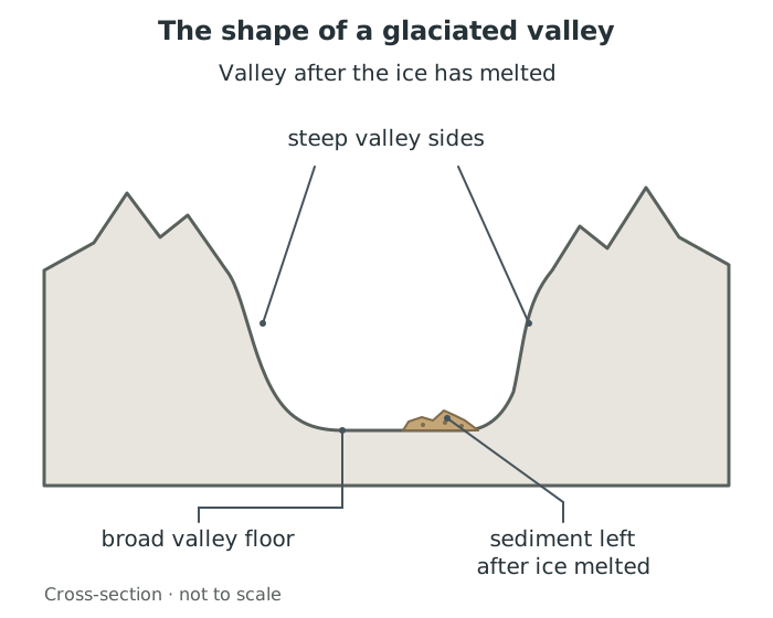
Past ice erosion left broad-floored, steep-sided valleys; sediment remained when the ice melted.
The Lake District, Snowdonia and the Scottish Highlands therefore combine upland relief with evidence of past glaciation. Glaciated does not mean that glaciers still cover these places today.
Climate is the usual pattern of weather over a long period. Western parts of the UK generally receive more rainfall than eastern parts, while northern areas have cooler summers than southern areas. The broad regional pattern is:
| Region | Summers | Winters | Rainfall |
|---|---|---|---|
| North-west | Cool | Mild | High |
| North-east | Cool | Cold | Low |
| South-west | Warm | Mild | High |
| South-east | Warm | Cold | Low |
Height adds another influence: upland environments are generally colder than nearby lower land. Exposed uplands can experience heavy rainfall and low temperatures. In the mountains of Wales and Scotland, wet conditions and temperatures fluctuating around freezing encourage weathering that helps break down rock.
The table describes broad regional tendencies. Mild winters in the north-west do not mean that its high mountains are free from snow or frost.
In upland and glaciated areas, steep slopes, thin soils and low temperatures make crop growing difficult. Sheep grazing is common because animals can use land that is difficult to cultivate. Some cattle graze lower valley floors.
Uplands also support forestry, with coniferous trees planted and managed for timber. Dramatic mountains, valleys and lakes attract tourists for walking, climbing and water sports. The Lake District is an example of a glaciated upland landscape used for tourism. Exposed rock provides opportunities for quarrying materials such as slate and granite, while high rainfall and valleys provide opportunities for reservoirs and hydroelectric power.
Gentler lowland terrain is easier to use for farming, buildings and transport. Farming has changed the landscape through drainage ditches on low-lying land, removal of trees and hedges, and the joining of smaller fields to accommodate larger machinery.
Many cities are in lowland areas beside rivers or estuaries. Liverpool lies beside the Mersey, and Bristol developed beside the River Avon near the Severn estuary. Water supplies and transport or trading opportunities helped make such locations attractive for settlement.
The relationship works both ways: physical characteristics influence human activity, but farming, forestry, settlement and reservoirs also change the appearance of the landscape.
| Landscape | Key characteristics |
|---|---|
| Upland | Higher, often rugged and steep; much resistant igneous and metamorphic rock |
| Lowland | Lower, generally gentler; mainly sedimentary rock |
| Glaciated | U-shaped valleys, steep mountain scenery and sediment deposits left by ice |
Upland and glaciated overlap: one describes relief, the other past ice action.
Describe distribution using directions and named examples, rather than simply listing places.
Treat upland and glaciated as overlapping categories: upland describes height and relief; glaciated describes the influence of past ice.
For an explanation, link a characteristic to its consequence: steep slopes and thin soils limit crop farming, so sheep grazing is common.
Use words such as ‘mainly’ and ‘generally’ for national patterns. Not every upland area has the same rocks, and lowland landscapes can include hills.
It can see this note and what your specification asks for.
Answers are free with an account.
1 free note left this week
Get more free notesYour answer sets when this note comes back for review, or marks it complete.
Was this note helpful?
Log in to tell us whether it helped, or to report a problem.
Last updated
Upland
An area of relatively high land, often with steep slopes, hills or mountains.
Lowland
An area of relatively low land, often with flat or gently rolling terrain.
Glaciated landscape
A landscape shaped by ice sheets or glaciers in the past.
Relief
The height and shape of the land, including differences in height and the steepness of slopes.
Geology
The rocks of an area, including their types, structures and origins.
Igneous rock
Rock formed when molten rock cools and solidifies, such as granite or basalt.
Sedimentary rock
Rock formed from accumulated material, often in layers that become compacted and cemented together, such as chalk, limestone or shale.
Metamorphic rock
Rock changed by heat and pressure without melting, such as slate or schist.
U-shaped valley
A valley shaped by glacial erosion, with steep sides and a broad floor.
Put your knowledge into practice — try past paper questions for Geography A
Upland
An area of relatively high land, often with steep slopes, hills or mountains.
Lowland
An area of relatively low land, often with flat or gently rolling terrain.
Glaciated landscape
A landscape shaped by ice sheets or glaciers in the past.
Relief
The height and shape of the land, including differences in height and the steepness of slopes.
Geology
The rocks of an area, including their types, structures and origins.
Igneous rock
Rock formed when molten rock cools and solidifies, such as granite or basalt.
Sedimentary rock
Rock formed from accumulated material, often in layers that become compacted and cemented together, such as chalk, limestone or shale.
Metamorphic rock
Rock changed by heat and pressure without melting, such as slate or schist.
U-shaped valley
A valley shaped by glacial erosion, with steep sides and a broad floor.