

Loading…
Loading…
Loading…
Eduqas GCSE Geography B · C112
Eduqas C112 · 2.3.3 Distribution of Weather Hazards Check the specification (PDF) (opens in a new tab)
The distribution of a weather hazard describes where it occurs. Its timing matters too: a region may face a much greater risk in one season than another. Changes over time are temporal changes; changes in location or the area affected are spatial changes.
There are two important timescales to distinguish. Seasonal changes repeat through the year, such as a tropical wet season followed by a dry season. Longer-term changes alter patterns over years or decades, such as a region experiencing more severe drought as temperatures rise. A seasonal pattern and a longer-term trend can operate together.
Tropical temperatures often vary less through the year than temperatures in the middle latitudes. However, rainfall can vary greatly, creating distinct wet and dry seasons.
Near the Equator, the trade winds meet in the Intertropical Convergence Zone (ITCZ), also called the tropical rain belt. Warm, moist air rises, cools and condenses, forming clouds and heavy rain. The belt shifts towards the region receiving the strongest solar heating: generally northwards during Northern Hemisphere summer and southwards during Southern Hemisphere summer.
A tropical location can therefore receive heavy rain when the rain belt is nearby, then become much drier when it moves away. Where sinking air dominates, cloud formation and rainfall are suppressed. This explains why rainfall patterns change across tropical regions during the year rather than everywhere having a wet season at the same time.
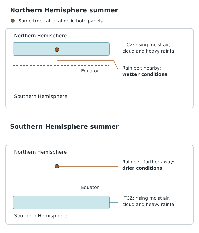
Seasonal movement of the tropical rain belt helps explain why rainfall at a tropical location changes through the year.
Seasonal wind changes also produce monsoons. A monsoon is a large-scale seasonal wind pattern, not a single storm. In affected regions, the summer monsoon brings moist air and substantial rainfall, while the winter monsoon brings much drier conditions. The arrival, duration and strength of the rainy season are therefore important to water supplies and farming.
Drought is a shortage of water that builds up over time. It can last from weeks to several years. A normal dry season is not automatically a drought: rainfall and water availability must be considered against what is usual for that region.
If seasonal rains arrive late, end early or are unusually weak, they may not replace the water lost during the dry season. Soil moisture declines, crops have less water available and rivers or reservoirs may fall. If poor rainy seasons follow one another, the shortage can become prolonged.
Different measures reveal different parts of this process:
These do not necessarily begin or end together. Rain may return before depleted water stores recover. Equally, low reservoir levels can reflect water use as well as rainfall shortages.
Drought also connects with desertification, the degradation of land in dry regions. Prolonged water shortages can reduce vegetation and make land more vulnerable to degradation. However, drought is a climatic water shortage, whereas desertification is a change in the condition of the land; they are not interchangeable terms.
Climate change can alter both rainfall patterns and the rate at which water is lost. Some regions may become wetter while others become drier, so there is no single drought trend for the whole of the tropics.
Higher temperatures can increase evaporation from the ground. This can intensify soil drying even where the change in rainfall is small. As soil becomes drier, the air above it may heat further, increasing evaporation and worsening the shortage.
There is evidence of reduced precipitation across significant parts of Africa and South America. Agricultural and ecological drought have also increased in many regions, including much of Africa and eastern Brazil. Ecological drought means that insufficient water affects the natural environment, not just farming.
Future projections suggest that the area affected by drought will expand as global temperatures rise. Under high greenhouse gas emissions, affected regions could extend across Central America and the Caribbean, most of South America and most of Africa. These are projections, not a claim that all these places already experience the same trend.
The overall conclusion is that warming can increase drought risk, but its effects vary by location and by the type of drought measured. Rainfall, temperature, land use and water demand all matter. It is therefore harder to attribute changing river or reservoir levels to climate change alone than simply to recognise that a water shortage exists.
Tropical cyclones are intense, rotating low-pressure systems that develop over warm tropical seas. They generally form between about 5° and 30° north and south of the Equator. Warm ocean water supplies energy, while the Coriolis effect helps the storm rotate. Very close to the Equator, this effect is too weak for tropical cyclones normally to form.
The names differ by region, but the basic weather system is the same:
| Region | Common name | Examples of areas affected |
|---|---|---|
| Atlantic and north-east Pacific | Hurricane | Caribbean, USA and Pacific coast of Mexico |
| North-west Pacific | Typhoon | East and south-east Asia |
| Indian Ocean and south-west Pacific | Tropical cyclone, with regional naming variations | India, Bangladesh, northern Australia, Madagascar, Mauritius and South Pacific islands |
Cyclone activity is not evenly distributed between these regions. Atlantic storms, including those affecting the Caribbean and USA, usually account for less than 15% of global tropical cyclone activity.
Cyclones are seasonal because the conditions needed for their development, including warm seas, vary through the year. The broad Northern Hemisphere season is June–November, peaking in September. The broad Southern Hemisphere season is November–April. However, individual ocean basins have important differences:
| Ocean basin | Season |
|---|---|
| Atlantic | June–November |
| North-east Pacific | Late May/early June–late October/early November |
| North-west Pacific | Possible all year; main season July–November |
| North Indian | April–December |
| South-west Indian | Late October/early November–May |
| South-east Indian/Australian | Late October/early November–May |
| Australian/south-west Pacific | Late October/early November–May |
These are periods of typical activity, not guarantees that a storm will occur. The north-west Pacific is especially important because tropical cyclones can occur there throughout the year.
Tropical cyclones initially tend to move westwards and slightly towards the poles, carried by tropical easterly winds. Many eventually reach the middle latitudes, where westerly winds can turn their tracks eastwards. This produces a curved path rather than a straight route towards the Equator.
A storm may therefore form over an ocean far from the coast it eventually affects. Its track determines whether it remains at sea, makes landfall or threatens several coastal regions in succession. More than one storm can be active in the same ocean basin at once.
When interpreting a cyclone-track map, first locate the latitude bands where tracks begin. Then follow any direction arrows to identify westward movement and poleward curvature. Compare the concentration of tracks between ocean basins and check the dates covered by the map. A map combining many years shows a broad pattern of past activity; it does not predict the route of the next storm.
For temporal changes, describe when hazards occur: within the year or over decades. For spatial changes, describe where they occur.
Distinguish a normal tropical dry season from drought: drought involves a shortage of water compared with what is usual for that region.
Use basin-specific cyclone seasons where possible. Not every Northern Hemisphere basin has the same season.
Separate observed changes from future projections. Avoid claiming that climate change makes every region drier or necessarily increases the total number of tropical cyclones.
Explain a distribution using a linked chain: seasonal movement of the rain belt → reduced rainfall → declining soil moisture and water supplies.
It can see this note and what your specification asks for.
Answers are free with an account.
1 free note left this week
Get more free notesYour answer sets when this note comes back for review, or marks it complete.
Was this note helpful?
Log in to tell us whether it helped, or to report a problem.
Last updated
Temporal change
A change over time, such as a seasonal shift or a trend lasting several decades.
Spatial change
A change in where something occurs or in the area it affects.
Drought
A shortage of water that develops over time, commonly following rainfall below the normal level for a region.
Intertropical Convergence Zone
A belt of low pressure where the trade winds meet and warm, moist air rises, producing cloud and heavy rainfall. Its position shifts seasonally.
Monsoon
A seasonal change in large-scale wind patterns that produces contrasting wet and dry seasons in affected regions.
Desertification
The degradation of land in dry regions, making it less productive and more desert-like.
Tropical cyclone
An intense, rotating low-pressure weather system that develops over warm tropical seas. Hurricanes and typhoons are regional names for the same type of system.
Coriolis effect
The apparent deflection of moving air caused by the Earth's rotation: to the right in the Northern Hemisphere and to the left in the Southern Hemisphere.
Landfall
The movement of a tropical cyclone's centre from the sea onto land.
Put your knowledge into practice — try past paper questions for Geography B
Temporal change
A change over time, such as a seasonal shift or a trend lasting several decades.
Spatial change
A change in where something occurs or in the area it affects.
Drought
A shortage of water that develops over time, commonly following rainfall below the normal level for a region.
Intertropical Convergence Zone
A belt of low pressure where the trade winds meet and warm, moist air rises, producing cloud and heavy rainfall. Its position shifts seasonally.
Monsoon
A seasonal change in large-scale wind patterns that produces contrasting wet and dry seasons in affected regions.
Desertification
The degradation of land in dry regions, making it less productive and more desert-like.
Tropical cyclone
An intense, rotating low-pressure weather system that develops over warm tropical seas. Hurricanes and typhoons are regional names for the same type of system.
Coriolis effect
The apparent deflection of moving air caused by the Earth's rotation: to the right in the Northern Hemisphere and to the left in the Southern Hemisphere.
Landfall
The movement of a tropical cyclone's centre from the sea onto land.