

Loading…
Loading…
Loading…
OCR GCSE Geography A · J383
OCR J383 · 2.3.4 Check the specification (PDF) (opens in a new tab)
Weather describes atmospheric conditions from day to day; climate describes their long-term pattern. A rainy afternoon is weather, whereas the tendency for a region to be warm and wet throughout the year is part of its climate.
The world’s climatic regions are not scattered randomly. They form broad patterns related to latitude, although oceans, continents and mountains modify those patterns. Global atmospheric circulation helps explain them by moving heat and moisture between the equator and the poles.
Tropical climates lie close to the equator, including parts of South America, central Africa and South-east Asia. Temperatures are high throughout the year. Equatorial rainforest areas have rainfall in every month, while other tropical areas have distinct wet and dry seasons.
Dry climates are widespread immediately north and south of the tropical regions. Many hot deserts lie around 30° north and south, including the Sahara in North Africa and deserts across much of Australia. However, not all deserts are hot or subtropical: the Gobi in eastern Asia is a cold desert. The defining feature is dryness, not heat.
Temperate climates occur mainly in the middle latitudes. They include much of western Europe, parts of the USA and eastern China. Temperatures are generally less extreme than in continental interiors. The UK has a temperate climate, with rainfall throughout the year. Mediterranean climates are a type of temperate climate with dry summers and mild, wet winters; they occur around the Mediterranean Sea and in places such as California and parts of Chile.
Continental climates occur mainly in the interiors of northern continents, especially Canada and Russia. They have greater seasonal temperature contrasts than ocean-influenced temperate climates because they are farther from the moderating influence of the sea.
Polar climates occur at high latitudes in the Arctic and Antarctic regions, including Greenland and the northernmost parts of Canada and Russia. They are cold throughout the year and generally receive little precipitation.
These regions are broad patterns, not continuous strips with sharp boundaries. For example, the UK is much milder than many parts of Canada at a similar latitude because of the influence of the North Atlantic and warm ocean currents.
The Sun heats Earth unevenly. Near the equator, sunlight strikes the surface more directly, concentrating its energy over a smaller area. Towards the poles, sunlight arrives at a lower angle and spreads its energy over a larger area. This creates a temperature difference between low and high latitudes.
As air warms, it expands and becomes less dense than surrounding cooler air, so it rises. Rising air is associated with low pressure at the surface. Cold, dense air tends to sink, producing high pressure at the surface.
Surface air moves from higher towards lower pressure. This movement is wind. A larger pressure difference over the same distance produces stronger winds. Earth’s rotation deflects moving air through the Coriolis effect, so global winds do not travel directly north or south.
Together, uneven heating, pressure differences and Earth’s rotation produce a circulation system that transfers heat towards the poles. Air does not travel in one uninterrupted loop from the equator to each pole: a simplified model shows three linked cells in each hemisphere.
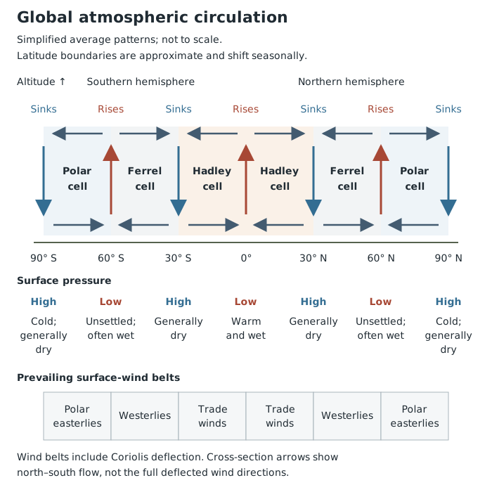
The three-cell model links rising and sinking air to pressure, prevailing winds and broad weather patterns. Latitude boundaries are approximate.
The Hadley cell extends from the equator to roughly 30° north or south. Strong heating near the equator causes warm, moist air to rise. As it rises, it cools and water vapour condenses into cloud droplets, producing frequent heavy rain and thunderstorms. Trade winds meet in this rising-air belt, called the Inter-Tropical Convergence Zone, or ITCZ.
At altitude, air moves away from the equator. It eventually sinks in the subtropics, creating high pressure. Descending air warms, making condensation and cloud formation less likely. Some air then returns towards the equator at the surface as the trade winds, completing the cell.
The Ferrel cell lies roughly between 30° and 60°. At the surface, air moves from subtropical high pressure towards lower pressure nearer 60°. Earth’s rotation helps turn this flow into prevailing westerly winds: winds blowing from the west. Near 60°, warmer air meets colder polar air and rises. Air returns towards the subtropics at altitude. The Ferrel cell therefore circulates in the opposite direction to its neighbours.
The Polar cell extends roughly from 60° to 90°. Cold, dense air sinks over the poles, producing high pressure. It flows towards lower latitudes at the surface as polar easterlies. Near 60°, it meets warmer air in a region of rising air and low pressure. Air returns towards the poles at altitude.
The model shows average patterns. In reality, cell boundaries move with the seasons, and individual weather systems interrupt the neat loops.
Where warm, moist air rises near the equator, cooling and condensation produce frequent, sometimes intense rainfall. This helps explain the wet climate of equatorial rainforest regions, including central Africa and parts of South-east Asia.
The opposite occurs beneath the descending branches of the Hadley cells. Subtropical high pressure suppresses cloud formation, helping explain the very low rainfall of the Sahara and much of inland Australia. Persistent sinking air can maintain long dry periods.
Around the boundary between the Ferrel and Polar cells, contrasting warm and cold air meet at the polar front. Rising moist air helps form travelling low-pressure systems. These bring unsettled weather to places such as the UK, including periods of heavy rain.
Large pressure differences can produce strong winds. In the middle latitudes, low-pressure systems associated with the polar front can bring stormy weather. High above them, the polar front jet stream helps guide their movement. If the jet stream meanders and weather systems become slow-moving, a region can experience prolonged rain and strong winds rather than a brief spell of unsettled weather.
Temperature patterns also reflect latitude and circulation. Equatorial regions receive strong solar heating throughout the year. Beneath subtropical high pressure, clear skies allow strong daytime heating, helping hot deserts reach very high temperatures. Clear skies also allow rapid heat loss at night, producing a large daily temperature range; some deserts can fall below freezing.
At the poles, weak solar heating and cold air produce very low temperatures. Movement of polar air towards lower latitudes can also bring unusually cold weather elsewhere, including snow in the UK during winter.
Global circulation therefore helps explain both usual climate patterns and the conditions that favour extremes. It does not mean every place within a climate region has identical weather, or that an extreme event happens continuously.
Unequal solar heating drives circulation and transfers heat towards the poles.
Cells: Hadley 0–30°; Ferrel 30–60°; Polar 60–90°. These are approximate boundaries.
Surface winds move from higher towards lower pressure. Earth’s rotation deflects them, creating trade winds, westerlies and polar easterlies.
For a distribution question, describe global patterns using latitude, continents and named regions rather than listing climate characteristics alone.
For an explanation, link the stages: heating → rising or sinking air → pressure → cloud and rainfall conditions.
Use approximate latitudes for circulation cells. Their boundaries shift seasonally rather than staying fixed at exactly 30° and 60°.
Strong winds depend on a large pressure difference over a distance, not simply on low pressure.
Distinguish a region’s usual climate from extreme weather: a temperate climate can still experience storms, heatwaves and exceptionally heavy rainfall.
It can see this note and what your specification asks for.
Answers are free with an account.
1 free note left this week
Get more free notesYour answer sets when this note comes back for review, or marks it complete.
Was this note helpful?
Log in to tell us whether it helped, or to report a problem.
Last updated
Weather
The day-to-day conditions of the atmosphere, including temperature, precipitation and wind.
Climate
The long-term pattern of weather in a place, usually described using averages and variations over at least 30 years.
Global atmospheric circulation
The large-scale movement of air that redistributes heat and moisture around the Earth.
Atmospheric pressure
The force per unit area exerted by the weight of the air above a surface. Rising air is associated with lower surface pressure; sinking air with higher surface pressure.
Pressure gradient
The difference in atmospheric pressure over a distance. A steeper pressure gradient produces stronger winds.
Circulation cell
A large-scale pattern in which air moves at the surface, rises, moves at altitude and sinks, forming a circulation loop.
Coriolis effect
The deflection of moving air caused by Earth’s rotation: to the right in the northern hemisphere and to the left in the southern hemisphere.
Prevailing wind
The direction from which the wind most commonly blows in a place.
Inter-Tropical Convergence Zone
A belt near the equator where trade winds meet and warm, moist air rises, producing clouds and heavy rainfall.
Jet stream
A narrow band of very fast-moving air high in the atmosphere that helps guide weather systems.
Put your knowledge into practice — try past paper questions for Geography A
Weather
The day-to-day conditions of the atmosphere, including temperature, precipitation and wind.
Climate
The long-term pattern of weather in a place, usually described using averages and variations over at least 30 years.
Global atmospheric circulation
The large-scale movement of air that redistributes heat and moisture around the Earth.
Atmospheric pressure
The force per unit area exerted by the weight of the air above a surface. Rising air is associated with lower surface pressure; sinking air with higher surface pressure.
Pressure gradient
The difference in atmospheric pressure over a distance. A steeper pressure gradient produces stronger winds.
Circulation cell
A large-scale pattern in which air moves at the surface, rises, moves at altitude and sinks, forming a circulation loop.
Coriolis effect
The deflection of moving air caused by Earth’s rotation: to the right in the northern hemisphere and to the left in the southern hemisphere.
Prevailing wind
The direction from which the wind most commonly blows in a place.
Inter-Tropical Convergence Zone
A belt near the equator where trade winds meet and warm, moist air rises, producing clouds and heavy rainfall.
Jet stream
A narrow band of very fast-moving air high in the atmosphere that helps guide weather systems.